


2 Login
|
Delimitation of land in public propertyDelimitation of land in public state property and land
|


|
Delimitation public property land - the process of appurtenance identifying to land in public ownership, including determining the scope of ownership (public and private), establishing the boundaries public property land, development of cadastral documentation for authentication of land rights, and registration of land in public property and administrative units of level I and II, including areas in the real estate register.
Land in public state property - lands of national interest where the property rights belongs to the state. Land in administrative units property - land of local interest where the property rights belongs to the village (commune), city (municipality) administrative district Gagauzia. In accordance with the support program developed by the Government, the delimitations projects of land in state public property and land in public property of administrative units, aim to identify effective management, transparency and protection of public lands. Necessity. Lately the illegal privatization of publicly owned land has increased significantly, due to the lack of a well defined informational system, management by central and local authorities of these lands. Thus, land in state public property and land in local administration districts property, can not be monitored and protected, as long as is not ensured correct data evidence on the material boundary. Therefore, the failure of delimitation works on land in public property, involving a large number of misdoings (unauthorized management of land, not imposing tax, illegal privatization, undermining investment, budgets does not accumulate the revenues, etc..) Purpose. The delimitation program of land in state public property and land in public property of administrative units aims:
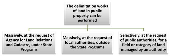 The State Planning Institute for Land Management is responsible for ensuring the execution of the work of delimitation of land in public ownership, providing methodological support, will determine the composition, content and manner of performing work of delimitation in cooperation with the Agency for Land Relations and Cadastre shared with public authorities, central and local public administration authorities of level I and II.
Drafts delimitation of public property land completed / in progress by The State Planning Institute for Land Management in 2008 so far:  Localities where The State Planning Institute perform delimitation works of land publicly owned:  Results. After the execution of the delimitation works are expected following results:
CADASTRAL PLAN
of land in public property of administrative unit
Hînceşti, district Hînceşti, delineated in boundary
land sector 5301204
 CADASTRAL PLAN of land in public property of administrative unit Mingir, district Hînceşti,
delineated in boundary land sector
5345201, 5345203, 5345401, 5345402
 |